The photos from these parts of our trip are now on the blog and also be viewed by following these links:
Banos:
Cuenca:
Cajas National Park:
Tuesday, 29 December 2009
Cotopaxi to Banos
After our night in the brothel in Machachi we cycled to Cotopaxi National Park, named after Volcan Cotopaxi, an active volcano sitting at 5897m. The route was along the Panamerican Highway – the main highway through South America. The Panamerican Highway was sadly smelly, hot, hilly, dirty and tiring! The majority of the traffic was buses and lorries. They must use some dirty fuel here, because all the exhausts were spewing out black fumes all over us. And it was Chris’s birthday...happy birthday!

We took one of the first opportunities to get off the main road, and followed a small track up towards Cotopaxi National Park. It was so nice to be away from the traffic! We ended up camping for two nights in the national park in a nice spot with a great view of Cotopaxi. It looked beautiful in the evening, shrouded mysteriously by golden clouds. While in the national park we went for a few walks, and at 3500m we could definitely feel the effects of the altitude! This perhaps wasn’t helped by the food we were eating...as our decision to camp had been entirely made on the spot we weren’t very prepared and all our meals for two days consisted of some combination of rice, mango and nuts. Cold and congealed mango flavoured rice for breakfast...gourmet!

By the time we decided to leave Cotopaxi it was clear that Chris’s leg was causing him a few problems. He has had a recurring groin injury for about 4 months now. We had hoped that a few days off in Quito would help to reduce the problem, by the uphill day on the Panamerican made sure that this wouldn’t be the case. So we decided to cycle back to the Panamerican and get a bus to Banos, a small city a few hours south. But first we had to find our way back to the road...this proved to be very difficult! The guy who we had paid for camping told us that the route to the camp spot was circular, so we decided to leave the way we hadn’t come. This was a bit of a mistake, the road was a dirt track (as it had been on the way up, but the way down turned out to be much worse). For about thirty minutes we fought our way down the worsening track, which led us through ditches, across fields, to dead ends and passed dogs determined to chase us and yap at our heels as we peddled frantically past. Eventually we saw a hopeful looking road. Chris went ahead to investigate, and as I was struggling up one of the hills I saw him coming back towards me. He reported, not very calmly, that at the end of that road there was a 'big f*****g gate that was f*****g locked!' Armed with rocks and big sticks, we faced the dogs again to ask at a nearby farm how to get back to the main road. The friendly farmer told us we should simply lift our laden bikes over the 12 foot gate. So...back again past the dogs, weapons at the ready (unused thankfully) and to the gate, which now was miraculously open! Eventually the road did lead back to the Panamerican, where we managed to flag down a bus. The bad luck wasn’t over yet though...

On the bus journey of woe, Chris’s expensive camera was stolen. Luckily, only the night before we had uploaded photos to the laptop, so at least not many photos were lost. But after a birthday cycling along the Panamerican, two days of eating rice and mango, an injured leg and a frustrating morning of dead ends and furious dogs this news obviously didn’t go down well. We stopped at a restaurant and ate more rice while we contemplated our options and worked out which dirty scoundrel had been the thief. After an hour or so of this we decided to continue on to Banos.
Banos turned out to be a lovely little town, and restored our good spirits. The town is situated right at the bottom of a valley with huge hills all around it. Just above the town is the active volcano Tungurarhua (meaning ‘throat of fire’), it is an impressive sight. Banos is so named because of the natural therapeutic mineral baths there. We visited them a number of times, hoping they would help Chris’s leg to heal. Even if they didn’t, it was fun and refreshing to alternate between the hot, warm and freezing pools. We found a great food market in Banos – the central market, where lunch was always less than $4 for both of us. Guinea pigs were a local delicacy, and although we didn’t try any as they were quite expensive, we saw them being cooked whole on big stakes over fires. They actually smelled quite nice! After a few days in Banos we felt refreshed from our traumatic few days and ready to face the rest of Ecuador. Next stop...Cuenca.

Road up to Cotopaxi National Park
We took one of the first opportunities to get off the main road, and followed a small track up towards Cotopaxi National Park. It was so nice to be away from the traffic! We ended up camping for two nights in the national park in a nice spot with a great view of Cotopaxi. It looked beautiful in the evening, shrouded mysteriously by golden clouds. While in the national park we went for a few walks, and at 3500m we could definitely feel the effects of the altitude! This perhaps wasn’t helped by the food we were eating...as our decision to camp had been entirely made on the spot we weren’t very prepared and all our meals for two days consisted of some combination of rice, mango and nuts. Cold and congealed mango flavoured rice for breakfast...gourmet!

Helen with Cotopaxi in the distance

View from our hike
On the bus journey of woe, Chris’s expensive camera was stolen. Luckily, only the night before we had uploaded photos to the laptop, so at least not many photos were lost. But after a birthday cycling along the Panamerican, two days of eating rice and mango, an injured leg and a frustrating morning of dead ends and furious dogs this news obviously didn’t go down well. We stopped at a restaurant and ate more rice while we contemplated our options and worked out which dirty scoundrel had been the thief. After an hour or so of this we decided to continue on to Banos.
Banos turned out to be a lovely little town, and restored our good spirits. The town is situated right at the bottom of a valley with huge hills all around it. Just above the town is the active volcano Tungurarhua (meaning ‘throat of fire’), it is an impressive sight. Banos is so named because of the natural therapeutic mineral baths there. We visited them a number of times, hoping they would help Chris’s leg to heal. Even if they didn’t, it was fun and refreshing to alternate between the hot, warm and freezing pools. We found a great food market in Banos – the central market, where lunch was always less than $4 for both of us. Guinea pigs were a local delicacy, and although we didn’t try any as they were quite expensive, we saw them being cooked whole on big stakes over fires. They actually smelled quite nice! After a few days in Banos we felt refreshed from our traumatic few days and ready to face the rest of Ecuador. Next stop...Cuenca.
Sunday, 27 December 2009
Photos From Ecuador
Since arriving in Ecuador we haven't done much cycling due to my stupid leg so after leaving Quito, we spent a day in Machachi walking around the market, then a few days near Volcan Cotopaxi before heading to Banos. The photos from these parts of our trip are now on the blog and also be viewed by following these links:
Quito:
Machachi:
Cotopaxi:
Enjoy!
Quito:
Machachi:
Cotopaxi:
Enjoy!
Thursday, 17 December 2009
Helen Arrives
I arrived safely in Quito after my 50 hour journey from Auckland to be met at the airport by Chris. I was relieved that my bike and luggage also made it, I had had 3 flights to catch and wasn’t that confident that they would arrive with me.
We stayed in Quito for 6 nights. The city is split into ‘old’ and ‘new’ areas; the new area is pretty touristy and more expensive, whereas the old area is much less touristy, cheaper and has plenty of beautiful old buildings, as well as steep, windy cobbled streets and plazas to explore. We spent most of our time wandering the streets, people watching and trying to learn Spanish. Very few people in South America speak English – even at Santiago airport I was surprised that people at the desks etc didn’t speak English. So, we are trying to teach ourselves the basics. We haven’t done too badly, and I usually feel quite confident after we’ve done some learning until I try to speak to someone and they reply too quickly for me to follow, and then all I can do is stare blankly and say ‘no entiendo’ and start to mime, while they try to explain in even faster Spanish. I think we will gain much more from the trip if we can converse with people, so we will keep learning and are planning on having some Spanish lessons somewhere along the way.
Despite our poor Spanish, the people in Quito were really friendly and always willing to help us out. I was surprised to see a lot of people (especially women) in traditional dress, it is a very colourful outfit consisting of long socks, a skirt and poncho, and completed with a small trilby hat with an extravagant peacock feather pinned to it. Often women had small children strapped to their backs with long strips of material – I only saw one pushchair while we were in Quito! There were very few beggars on the streets, which was another surprise for me. I had expected to see quite a lot. There were, however, plenty of shoe shiners. People who live in Quito must have the shiniest shoes in the world, on every street and in every plaza there were shoe shiners! People of all ages had their shoes shined; I think the youngest person I saw was a boy who looked about 2, and the oldest about 80! We were sitting in a plaza one day and were approached by two shoe shining boys. Although we were wearing flip flops, they offered to shine our shoes! They were very determined and even when we declined they got their polish and tried to shine the sides of our shoes. We eventually managed to send them away.
After an enjoyable time in Quito it was time to build our bikes, pack and leave. I was almost certain that I’d be unable to fit all my stuff into the two small panniers and one rucksack that I will be travelling with for the next few months (a challenge and a difficulty for any girl). Chris kindly said he’d take some of it for me, but between us we still seemed to have too much to carry! An amusing (in hindsight) few hours followed where we asked each other questions such as: “Do you think I’ll need this saw/ perfume/fishing rod/3 books/adjustable spanner/llama wool jacket?” The reply was usually “Do you think you’ll need it? Have you used it?” To which Chris usually responded “Well... I haven’t used it since Canada. But, you know, might come in handy somewhere.” We ended up being fairly ruthless and leaving the hostel staff with a nice pile of rejected items. The rest we managed to squash in or strap on somewhere.
It was time to leave! We decided to cycle from our hostel to the main bus station, and get a bus to our next destination - a town called Machachi, which is about 25 miles south of Quito. By doing this we hoped to avoid much of the traffic in and around Quito, and on the 4-lane highway out of the city. BUT...we still had to negotiate the busy streets of Quito. I felt quite apprehensive, mainly because I have no front panniers (bags) on my bike, so all the weight is at the back. Lifting it is almost impossible, and I had frightening images of myself doing wheelies while going up steep hills, and then falling over backwards while Chris cycled ahead obliviously. Luckily that wasn’t the case, and once I had got used to the crazy steering on my bike I was fine. We unknowingly picked a brilliant day to leave Quito (I wish I could say we planned it). Twice a month, all the streets in the city centre are closed to vehicles, and there is a cycling event. We picked one of these days! Even better – most cyclists were travelling the opposite way to us, so we had half to road almost to ourselves. There was a real mixture of people taking part in the cycling event, and some very unlikely characters too. The most memorable person was a guy who instead of having panniers on the back of his bike, had two huge speakers and a sound system! Very inventive I thought.
We managed to get a bus successfully, and paid only $1.50 for both of us and our bikes! We arrived in Machachi to find there was a huge food market going on, where we tried a lot of new food, most of it delicious. We also met a very giggly, chatty old couple (we didn’t understand anything they were saying) who we laughed with. After they had walked off the woman scampered back and stuffed $5 in Chris’s hand! He tried quite forcibly to give it back, but she was having none of it and just laughed as she trotted away. Everyone else was laughing too, and we felt quite bemused, but very grateful for her small and incomprehensible act of kindness. After the visit to the market we headed back to our hotel which we realised as the night wore on was actually a brothel, but for $7 who's complaining! The next morning we headed south towards Cotapaxi National Park.
Saturday, 12 December 2009
More Mexico Photos
These are my photos from Baja, Mexico. Click to see in Picasa. I'll hopefully add some captions soon. Enjoy!
Thursday, 10 December 2009
Photos from the USA
I'm now in Quito and have joined up with Helen for the South American Section of the trip! Helen has a netbook so I have managed to get a lot more photos on Picasa. These are the best from the USA, should have photo's from Mexico up soon, Enjoy! Click on the galleries to view from Picasa.
Border to San Fran
San Fran to Mexico
Border to San Fran
San Fran to Mexico
Monday, 30 November 2009
Desert Camp spot to San Lucas Cove
After leaving my desert camp spot the road saddly didn´t improve, its was a terrible combination of washboard and sand and my morale was pretty low, the views were great though! Around midday a pickup truck passed me that had a cyclist in the back and it stopped just ahead of me. I was pretty jealous that the guy had managed to get a lift for part of this terrible road. He got out of the pick up and we ended up cycling together for the next four days. The cyclist, Tomo from Japan had started about 6 weeks ago in Vancouver and was heading towards Patagonia. The road luckily improved slightly as the day wore on or maybe it was just the company making the expierence more bareable. We finally arrived at Rancho Grande, just outside Gonzaga Bay at around 2 and stocked up on some supplies and got ourselves some tasty beef tacos. We then cycled for another ten miles before finding a nice camp spot by the road.
The next day we got up early and carried on along the road, it was nice having some company although Tomo struggled a little with my accent. For our efforts and they were considerable we were rewarded with great views all day but saddly it was hard to enjoy them as it felt like I had an nuematic drill for a saddle. About half way through the day we got to Coco's Corner, a tire shop/campground/general reststop that was ran by the charismatic Coco who kept a journal of everyone who passed through. The drinks were overpriced but I had been dreaming of a cold drink all day so bought two cokes while Coco drew pictures of Tomo and I in his Journal. I got a chance to look in his journal and saw that only one other cyclist had been through this year and that was about 2 months previous so it was very lucky that i met Tomo on the road.
We regretably decided not to camp at Coco's since it was still early in the day and pushed on over the mountains back to the paved Route 1. The dirt road joined back up with Route 1 next to Chapala, which isn´t really a town, more of a reststop, but provided us with the chance to buy some water before cycling another 5 miles and setting up camp. The next day we made about 70 miles, it was nice being back on the pavement and with a tailwind the miles seemed to fly by. The desert scenery was nice but I was starting to yearn for something different.
We arrived at Guerrero Negro early the next day and I decided to take a day off. Tomo headed onwards deciding that Guerrero Negro wasn´t the nicest town to take a day off in. He was spot on really, it was a pretty ugly town but my body baddly needed a rest and I stayed at the Malarrimo Hotel and RV park for two nights. They charged me about 70 pesos which I thought was pretty reasonable since I had been charged 100 pesos at an earlier campsite with terrible facilities. While at the Malarrimo I luckily bumped into Jim and Liz from the Durango, USA and they invited me to come and camp with them at San Lucas Cove just passed Santa Rosalia. I actually had quite a nice time at the Malarrimo, there was an excellent fish taco stand just down the road and I was enjoying my current book about a woman who relocates to Tuscanny for part of the year!
The next day I had to wait until the bank opened since I hadn´t paid for my tourist card yet. I left around 11 but due to favourable wind conditions and the road being mosly flat I made about 85 miles and pulled off into the desert just as the sun was setting. The next day was quite scenic and I passed through San Ignatio, an oasis town in the desert, which was a nice change before pushing on to Santa Rosalia. There were some decent climbs after San Ignatio but I didn´t feel like I´d earnt the massive downhill down to the Sea of Cortez. The decent was a nice surprise but the road was narrow as per usual and the trucks seemed to fly round the bends at quite some speed! It was probably the most dangerous section of the road, the trucks were taking the downhill sections as fast as possible to get momentum for the uphill sections, an unusual strategy for such a big vechical but it seemed to work. I arrived at Santa Rosalia in the early afternoon, the town had a nice vibe and it would have been nice to stay but i decided to cycle another 10 miles to met up with Bill and Liz. I arrived just as it was getting dark and was invited to dinner with wild Bill and his wife, some friends of Liz and Jims. When I arrived I didn't look a guy you´d want to invite to dinner having just ridden 155 miles through the desert in two days without a shower, so a big thank you for the invite. Everyone was interested in my trip and we talked over some beers and great food about my motivations for doing the trip.
The hospitility that I recieved while staying with Liz and Jim from both them and their friends was amazing. I had the chance to take out a kayak and did some snorkling. I also went fishing for the first time with Jim, which was a great expierence and managed to catch a few different fish, which was more down to Jim than any skill on my part. During my stay everyone seemed to want to feed me, this seems to be the case everywhere I go, even at home, I'm not really sure how I manage to this but it's a good skill to have. After three relaxing great days I reluctantly packed up and headed south.
Friday, 20 November 2009
Some Recent Photos from Mexico
A selection of photos from the last few weeks in mexico.

I met Jim and Liz in a campground in Guerrero Negro and they suggested that I should come and camp with them at San Lucas Cove outside of Santa Rosalia. I had a great time relaxing, enjoying some great food, kayaking and fishing. Thank you both very much!

This is Tomo from Japan, who I spent four days cycling with, as he decends down to the paved Route 1 after three days on the dirt.

I met Joe and Bryan about 30 miles before Mulege and camped with them for 4 days at a mostly deserted beach in Bahia Conception. They are hoping to cycle down to Argentina then down through Northern Africa to Europe if they don't run out of money. You can check out thier story at thier website http://www.wekeepgoing.com/. Joe managed to catch a puffer fish with his make shift fishing set-up, a few days earlier Jim had told me they are poisonous and I've just read on wikipedia that they are the second most poisonous vertebrate in the world! So I'm glad we decided not to eat it and instead used it as bait.

A photo of Bryan, most touring cyclists don't look this well kept.

The beach we stayed at in Bahia Conception

Sunrise at the beach

A Tasty Crab cooking over the fire that we caught using the puffer fish as bait!

This inspired photo was Joes great idea.
Hopefully get some more photos online soon.
Thursday, 19 November 2009
Mexico! Mexicali to Desert Camp Spot
On the 31st of October I made it to Mexicali, and passed into Mexico. It was an eventful day, I woke up before sunrise as I wanted to get to the Mexican border early and get on a bus to San Felipe. On my way to the border I passed some cyclists and asked them if they knew of a nearby bike shop since I needed a few things and figured it would be less stressful getting them in the US. They directed me to Finish Line in El Centro. The guys at the bike shop were extremely friendly and I left in a pretty positive mood, I got a new chain, cassette, saddle and the boss threw in some innertubes and puncture repair kits for free. He also warned me that I should take my old chain since bike shops were going to be few and far between in Baja, Mexico. I told him that I´d never had a chain brake on me before and I should be ok . I would later regret this decision.
When I got to the border I knew I had to hand in my US visa waiver form so they´d know that I´d left the country. This turned out to be harder than expected. After following signs for the border crossing I ended up getting into Mexico before seeing any sign of US customs. I turned around and asked a US border control guard where I should go, he warned me not to hang around as he would have to call for helicopter backup and fine me $6000 or something like that, I´d obviosly came too far. I asked some of the Mexican customs staff and they said I would have to go back into the US to hand in my form. I did this and handed my form to a US customs guard and then explained to him that I didn´t want to actually go back into the US and he let me out of a back door back into Mexico that saddly opened into a pedestrian only area with a rotating door that I couldn´t get my bike through! I then had to bang on the custom window and they let me out of another door and I was finally in Mexico. I then picked up a tourist card and headed to the bus station. I got a bus to San Felipe as I didn´t want to cycle out of Mexicali. The bus driver let me put my bike, panniers still attached under the bus for no extra few which was refeshing.
I got to San Felipe in the dark and rode into town. It was halloween so everyone was in good spirits and the town had a nice vibe. I headed to the sea front and bought some fish tacos, a Baja speciality. Saddly I think the fish in my tacos had been sitting around for a long time. I got talking to some Americans at the taco stand who let me camp with them for free. The next morning after picking up some supplies I headed towards Puertecitos. I set off pretty late and ended up camping at a ranch off the highway as I needed to get some water. When I arrived at the ranch an old lady said I could camp there for free. The bathroom and shower building had no roof and of the 5 toilets in the mens bathroom. Only one had the winning combination of a tiolet seat and a door. The shower tunrned out to be a hose pipe but it was still nice to have a wash. On waking I was informed by the more buisness minded son of the old lady that they normally charge 200 pesos but are willing to charge me only 100 pesos (around 5 pound) for the camping. I told them what the old lady had said but he told me she wasn´t in charge of camping. I paid the money and was then overcharged for 3 bottles of water and was glad to leave.
The road out of the ranch was pretty rough and half way along it my foot suddenly hit the floor and I heard a horrible noise that turned out to be one of my chain links coming apart. When inspecting the chain it became apparent that it hadn´t been connected properly at the bike shop, which made me pretty angry since they had warned me to take my old chain, probably as an insurance against their terrible mechanic skills. Since I didn´t have a spare chain and stupidly had lost my spare link I couldn´t fix the chain properly. I decided regrettably that I´d have to try and fix the chain the best I could and head back to San Felipe and get a bus to Ensenada, where the nearest bike shop was located. After reassembling the chain link that had broke I managed to get five miles towards San Felipe before it snapped again and part of it was lost in the dirt! I then disassembled another link and reassembled it and it actually felt pretty solid. I decided that I wouldn´t need to go the bike shop after all and turned around and started heading south again, the locals probably thought I was pretty mad!(the chain hasn´t snapped yet after about 350 miles).
After the chain problems I ended up getting to Puertecitos as it was getting dark and was informed there was no longer a campsite or restaurant but I could find both another 5 miles down the road. I arrived at the campground and treated myself to a delicious meal of fish, rice and beans. I asked how much camping was and they informed me it would be 130 pesos ( around 6 pounds) which i said was expensive for one guy on a bicycle so they said they wouldn´t charge me unless the boss returned from San Felipe.
The boss didn´t return before I left very early in the morning and I was back on the road at about seven. I asked the guy at the campsite the night before if there was anywhere to get water on the road south and he said yeah, lots of places! The road south turned out to be worse than I thought it would be. I knew it would be a dirt road but I didn´t anticipate it being one of the worst roads I´d ever cycled on. At about midday I came to the first settlement were I expected there would be a shop for me to buy some water. Saddly there was nothing, an american guy name George who lived in Baja for half the year saved the day and let me fill up my 10 liter water bag and also gave me a coke.
I was pretty tired from the early start and the terrible roads so decided to call it a day around 2 o´clock. I pulled off into the desert and found a nice place to camp amongst some cool looking cacti that were being pollinated by some even cooler humming birds. The sea looked pretty close so I decided to see if I could hike to it and go swimming. I followed a dry riverbed for about 20 minutes before turning around deciding that maybe the sea wasn´t as close as it looked. I managed to follow my footprints to what I thought was the place I left my bike and was alarmed when it wasn´t anywhere to be seen! I got pretty worried thinking maybe it had been stolen and started running around the dessert before finally locating my bike! I´d actually passed it without noticing and decided that I wouldn´t do anymore desert hiking.
Saturday, 7 November 2009
California City to Big Bear City
Will try and add some photos soon
After our adventure in Sequoia National Forest Tom and I cycled towards Apple Valley through lots of desert. We stayed the first night outside California City after treating ourlselves to some great burritos from the Burrito van. I'm normally get nervous when camping by the road even though I do it a lot. When setting up camp on that particular night I mentioned to Tom that most people are probably pretty scared of two guys in the middle of the desert with headlamps on, so I probably don't have much to be scared about. One advantage of cycling in the desert is that once your out of a town you can basically camp anywhere and it's legal in a lot of places because its government land. From California City we headed down 58 and past the no cyclists sign(there was no other road to take) until we had a chance to get off it, just before the town of Boron, a town built next to one of only two Boron mines in the world! Tom treated me to a great icecream(thanks) and we popped into the Boron Museum which was run by a well meaning lady who told us the best way to get to Apple Valley and lots of other interesting facts about the area until we were about ready to cry. Tom knew a girl who lived in Apple Valley and my leg was hurting a little so we decided to try and hitch so we would get there before dark. After about half an hour a guy picked us up and dropped us 30 miles closer and so we managed to do the last 15 as the sun set arriving in the dark. We stayed the next three night at Ambers house and had a blast.
The first night we were pretty tired and stinking so we showered and slept! The next day we had a little tour of Apple Valley and went to see an interesting college, CalEarth, that built buildings from earth and sandbags. The guy who ran the college was from Sunderland, a town not far from my home town, it was quite a surprise to hear my local accent. We planned to go to some local hot springs that night but ended up drinking lots of sangria and dressing up using Ambers extenisive collection of fancy dress outfits. Tom looked fabulous as Wonderwoman and I made a great nurse. The next day Amber drove us to some local hot springs which were a blast. I think they were the New Jack City hot springs. After a short hike through some desert scenery we came to a river with 4 different pools of different temperatures. On arrival Tom and Amber stripped naked, I didn't want to seem like a prude so followed suite. The atmosphere at the hot springs was very friendly and we met some interesting people.
Amber was a great host and it was a shame to leave the next day, we finally set off at around two and headed towards Joshua Tree National Park on the 18 and camped just after Lucerne Valley. The next morning we changed our plans and headed up a pretty big 4000 feet climb to Big Bear City to meet up with some of Tom friends to do some rock climbing. The climb didn't seem too bad and we camped a few miles up a dirt road where we stashed our bikes and were picked up the next morning for a great day of rock climbing. The rock climbing was really a lot of fun, it was great watching Tom and Nick climbing as they were pretty good and it was good to get a chance to do some myself. We woke early the next morning as Toms friends had to head back to San Diago for work. I was feeling a little rough from the beer the night before but this feeling was remedied pretty quickly with some breakfast burritos. Tom and I head down to Big Bear city and found out about a dirt road that headed down to Yucca Valley and then headed a little ways down that road before setting up camp.
Friday, 23 October 2009
Time Lapse from Redwords National Park
Tom managed to attach his Canon Powershot to his helmet with his Gorrilapod so we captured some time lapse photography in the Redwoods National Park. Enjoy!
Sequoia National Forest - a few days on the dirt
From Sequoia National Park Tom and I were able to get a lift to Bakersfield with Ari (thanks!) we then started heading east on the quietest roads we could find. We passed fields and fields of commercial agriculture and Tom helped himself to a few tasty oranges before we entered the sierra foothill at which point we thought we found a good camp spot by the road. On closer inspection the ground was covered with used shotgun shells and then we heard some guns being fired off and just round the corner a family of Mexicans were doing some target practice! We decided to keep cycling for a few miles before finding a spot that was mostly out of sight of the road. Conveniently right at the bottom of a climb that we would be embarking on the next morning.
The next day we rode through some rolling hills in the early morning through Caliente, CA, into a gradual climb through a beautiful canyon (with an excellent tail wind) and ended up at Twin Oaks at which point we found out that a road we thought we could take east dead ended just out of town. A kind gentleman from the town, the local security guard, gave me a map of the county and we found some dirt roads that we could cycle on to carry on east and so began our adventure in the Sequoia National Forest.
From Twin Oaks General Store we cycled up hill for about six miles to the fire station and saw a bob cat on route. The lady in the general store said it would be only 2 miles, she also warned us not to enter the wilderness because of 'lions, tigers and bears oh my!'(exact quote). At the fire station we both loaded up with around 12 liters of water. We then headed into the Sequoia National Forest on Piute Mountain Road, very curious what the following days would bring. This is one of the beauty's of creating a travel itinerary on the fly. It lends to much more spontaneity and randomness.
The following pictures were taken about one mile into the three mile push that lay ahead.


We ended up making it to a really nice camp spot just as the sun was setting.


The next morning we woke up just before sunrise and were greeted by a magnificently painted skyline.

We embarked on what would end up being a 6 mile slog, switching from pedaling to pushing, up into the Sierra Nevada mountains of Sequoia National forest. We met several hunters along the way, good ole boys who gave us various inncorrect distances to the top of the climb. "Oh it's 1/2 mile till the top then smooth sailing" said one, "That guy was bull shitting you, it's four miles to the top!", and the third "you got a lot more of the same " as we pushed by him, swearing and panting all the while. Two mile later we reached the top and ecstatically crested the hill and begin an exciting 5 mile downhill. Then we entered what seemed to be an alpine valley that was filled with Jeffery pine trees and giant granite boulders jutting out of the landscape. The photo below is of a ranchers cattle we wondered upon grazing in a field.

We passed a sigh for the Pacific Crest Trail boasting a waterhole and campsite 3/4 of a mile south so we pushed the bikes into the forest to settle down at about 3 P.M. There was a flat spot for a tent but the water at the waterhole was less than desirable and we decided to make do with what we'd brought up the hill. We woke up early the next day as we weren't sure what road conditions and climbs we would encounter. The first few miles were undulating before we started a magnificent decent down to the Kelso Valley (the three picture below were taken on the way down).

A welcome sight.

Tom ripping.

Tom is the small cyclist in the bottom left corner.

The Kelso Valley road(see photo above) started with a two mile hill before descending for around six miles to Jawbone Canyon Road. Jawbone Canyon Road was a blast. There was a fairy gentle uphill for six miles before a ten mile downhill to Route 14. The downhill was pretty crazy and we hit speeds of 40-45 mph which was pretty scary but also a whole lot of fun!
This blog entry was brought to you by Tom and Chris
Sunday, 11 October 2009
Photos from the US - San Francisco
I ended up spending about 5 days in San Francisco enjoying the Hardly Strictly Bluegrass Festival. Here are some photos from my time in the city:


Tom plays his banjo while I look in a book shop and try and find maps for South America. The fifth bookshop I got to had some.

I met Toms friend Adam in San Francisco, he very generously gave me and Tom a lift to Sequoia National Park.

I met Arthur on the Oregon Coast and we met up again at the Festival and had fun celebrating his 21st birthday

The mushroom selling guy, I didn't give him any business

I did give the burrito selling people some business tho and had no regrets

A dog enjoying some bluegrass

While in the city some of Toms friends kindly put us up, the lived in a very cool converted warehouse.


Toms friend Krissy performs with a wand

Tom performance wasn't quite as polished

Some cool looking guys at the festival

The festival was popular with cyclists
Photos from the US - Sequoia National Park
I've spent the last week at Sequoia National Park and its been one of the highlights of the trip so far. Me and Tom went on a 3 day hike into the mountains and saw some amazing scenery. Here are some photos from the week (you may need to click on some of them to see the whole photo):

The biggest tree in the world!

On the hike Tom managed to catch a few small fish for us to eat.

Sunset from our campspot in the mountains

The scenery was pretty breathtaking

A tree on the Generals Highway

View after a tiring climb from Pear Lake

Great Scenery in the Tablelands

Riding down the Generals Highway

Great campspot by one of the many lakes we passed

At the trailhead
Monday, 7 September 2009
Jasper to Revelstoke - The Icefields Parkway
Overview
Scenery - 10
Road Conditions - 8
Free Camping opportunities - 9
Hills - 8
Services - 6
I decided to hitch into Jasper from Mcbride to give my leg some time to rest before paul would arrive a day later. When I arrived in town I headed to the Park HQ to ask about camping, they said it would $27 a night per site. Since I was by myself this would have been rediculously expensive so I set off around town to find someone to share a site with. I found Jethro, a guy from England hitchhiking and working his way around the world. We decided to meet at the campsite a few hours later. When I arrived at the campsite I found out that there were cheaper walk in sites available for only $22.50! Camping at Jasper didn't end up being that expensive in the end as when Paul arrived we split the cost three ways and then recruited another english guy for a night and since no one was checking who was on the site we stayed for free on our last night.
Jasper was a nice enough place to spend a few days but had little character. On our last day in town we went to the aquatics centre. We went in the early afternoon and it was $5 which is pretty reasonable. I'm not sure what I was expecting from the aquatics centre but I was a little disappointed. The hot tub was certainly hot and I spent most of my time in there trying to soothe my aching muscles. I tried to massage my hamstring that was hurting but I realised that it may have looked like I was massaging something else so I soon stopped that. After about 40 minutes in the hot tub I decided to get my 5 dollars worth and have a go on the slide. After coming down feet first I was a little dissatisfied so decided to go down head firt. On arriving in the pool at the bottom I was promtly told off and as I stood up I realised my shorts had fallen down, I pulled them back up and made for the exit.
Jasper was the beginning of the Icefields Parkway which would turn out to be the highlight of the trip so far. On the 25th we headed out of Jasper, a little ways down the road there was a checkpoint to pay the park entrance fees. I ended up getting a two day pass for $20, Paul just cycled straight through and didn't have to pay. We ended up cycling about 45 miles that day and headed down a dirt road to a large clearing that we think must have been a lake once. It had a picnic table and a set of antlers, everything you'd want in a campspot I'd say.
.JPG)
The next day I managed to get up pretty early and was only the road by about 7.45. The roads are empty this time of day and I would definetly recommened getting up early if you cycle the Icefields Parkway as it really improved the expiernce for me. It was great cycling with zero traffic and the views just kept getting better as the day went on and it ended up being one of my best cycling days ever!
.JPG)
In the early afternoon I reached Sunwapta pass(2030m) which wasn't actually that bad and the downhill on the other side was awesone (probably best to come from jasper to get gentler hills).We ended up camping at Rampart Creek Campground.
The next day I had good intention of getting up even earlier but when my alarm went off at 6.00 it was still dark out so I decided to stay put. I ended up getting about 6.45 and saw Paul in his new hammock with a tarp wrapped around him for warmth, it was pretty cold at night in the rockies, probably the coldest of the trip so far. The scenery was really breathtaking for the first hour after I'd set off.
.JPG)
The only downside of setting off early was sacrificing the feeling in my fingers! Bow Pass was a little tougher than Sunwapta and I put my headphones on and put on some Modest Mouse, which normally does the trick, I decided that I wouldn't stop cycling until the album had finished. After about half an hour and in some distress I checked my MP3 player and there were still 6 songs left! I quickly decided that my first idea had been too optimistic and stopped for a break after the next song had finished. I passed quite a few cyclists on the way up but none of male ones waved, I suppose it must have hurt their ego's to see that a guy on a loaded bike had just done the same climb as them. There wasn't much of a downhill after the pass but there was a very scenic bright blue lake called Bow Lake. We stayed at Mosquito Lake Campground that night and found a spot away from the other sites next to the river with a picnic table which had great views of the surrounding mountains. When the sun went down the sky turned red and looked very impressive.
.JPG)
I foolishly slept under the stars that night and my sleeping bag developed a layer of ice on its outer. The down actually didn't get wet and I managed to dry it out when the sun came out later in the afternoon and it was like new.
.JPG)
There was about 15 miles left of the Icefields Parkway, of which I savoured every mile, to cycle before we would turn onto the very busy and annoying TransCanada Highway. The first section of Transcanada wasn't the worst because of the great downhill. After a very short climb to Kicking Horse Pass (1627m) there was a pretty nice downhill all the way to Field.
to be continued.....
Some Recommended Equipment
 If you haven’t done much bike touring before it’s sometimes hard to find the best equipment for the job, here are some of my recommendations. I have used all these products for at least a hundred days on the road.
Topeak Mountain Morph Mini Pump
Although not the smallest mini pump around, the extra hundred grams or so won’t make much difference to your overall weight and having properly inflated tires will have a noticeable impact on your average speed. This pump folds out in to a mini track pump so you can pump against the floor, which makes a massive difference if you’re trying to pump your tires to a decent pressure. I have had this pump around 5 years and it has come with me on every bike ride in that time and still works like new.
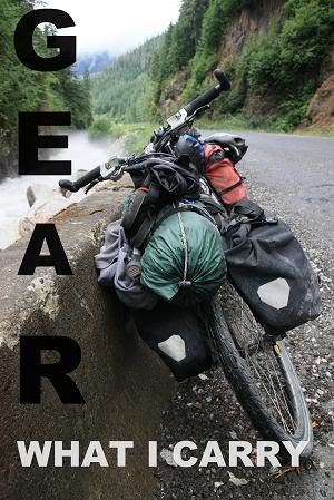
Old Man Mountain Pannier Racks
This company makes great bike racks and has a great customer service reputation. They provide the best solution for putting racks on bikes without rear rack eyelets (they are attached to the V brake bosses and through the wheel quick release skewer – see photo at top of post) and putting a front rack on a suspension fork for off road touring. I have used their racks for all of my bike tours and have had no problems. They are available through Carradice and St John Street Cycles here in the U.K.
Topeak Alien Multi-tool
This multi-tool has all you need to fix most roadside repairs and doesn’t really have any faults that I can think of. Highly recommended.
Feathered Friends Winter Wren Sleeping Bag
This is an unusual sleeping bag in that it can be worn as jacket, well if you don’t mind looking a little silly. It has arm holes and a front zip and a draw cord at the bottom so can it can be fastened around your waste, it's nice to be able to read or cook around camp in your sleeping bag. It doesn’t weight much but if you choose to take this instead of a sleeping bag and an insulated jacket the weight saving will be even greater. It works best as a jacket if worn under another jacket, a waterproof for example, to give it some sort of shape. I would recommend getting the Epic outer fabric, it has proved to be extremely water resistant. I use this under a tarp without a bivy bag and am confident that even if the outer fabric gets damp the down will stay dry. This bag is also extremely warm, I’ve slept in it with very little on below zero degrees Celsius under a tarp and been warm.
MEC Panniers
I have used the MEC PF-21 Cordura Cycling Panniers from MEC (they’re a massive outdoor retailer in Canada for those reading in the UK), which have proved to be extremely durable for the price. The attachment mechanism is basic but it works extremely well and they sell spare clips but I doubt you’d ever need them. I have also used these off road for long periods without any problems. I would recommend these for anyone looking for a set of small non-waterproof panniers.
Map Your Ride
Before going for a bike ride/run it is nice to be able to accurately calculate how far your going to ride/run and to be able to see an elevation profile for the route. To do this I have been using two websites:
http://www.mapmyride.com/
http://www.mapmyrun.co.uk/
Both website work well and are very similar in many ways. When using either website I would recommend selecting the auto follow roads option. As the name of this option suggests, it means that when your mapping a new route and select a new location on the map, it will find the shortest route sticking to roads.
Mapmyrun.co.uk
I used to prefer mapmyrun.co.uk because its auto mapping was much quicker(it still is quicker but the difference is less noticeable), this is probably because is gets less traffic and because the website has less bells and whistles. It never seems to fail to auto route which mapmyride.com has on some occasions. It also gives a basic but adequate elevation profile.
Mapmyride.com
Mapmyride.com seems to have improved its auto routing recently but now has floating advertisements which can be annoying. It has a much better elevation profile diagram which is colour coded with different colours used for different percentage inclines and also gives you figures for elevation gain/loss. The map at the start of this post is from one of my recent rides, I mapped the route in advance on mapmyride.com, once you are a member they have an option for embedding your maps into blogs which is helpful if you have a blog or website but most people probably won't use.
Conclusion
I use and would recommend both websites. I use maymyrun.co.uk when I'm in a rush and mapmyride.com when I want a better elevation diagram and the option to embed the map into this blog.
Sunday, 6 September 2009
Favorite Photos
If you don't want to look through all my photos, these are my favorites so far for Canada.
.JPG)
.JPG)
.JPG)
.JPG)
.JPG)
.JPG)
.JPG)
.JPG)
.JPG)
.JPG)
Subscribe to:
Posts (Atom)